Acronyms:
ALOS - Advanced Land Observing Satellite
AMSR-E - Advanced Microwave Scanning Radiometer - EOS
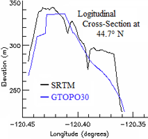
DEM - Digital Elevation Model
EOS - Earth Observing System
ERS - European Remote Sensing
ESA - European Space Agency
ESDR - Earth System Data Record
GTOPO - Global Topography
JAXA - Japan Aerospace Exploration Agency
JERS - Japanese Earth Resources Satellite
JPL - Jet Propulsion Laboratory
NASA - National Aeronautics and Space Administration
NSCAT - NASA Scatterometer
PALSAR - Phased Array type L-band Synthetic Aperture Radar
QuikSCAT - Quick Scatterometer
SAR - Synthetic Aperture Radar
SRTM - Shuttle Radar Topography Mission
SSM/I - Special Sensor Microwave/Imager
USGS - United States Geological Survey