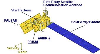
Follow this link to skip to the main content
jpl header
JPL Home Earth Solar System Stars & Galaxies Science & Technology
JPL Email News RSS Podcast Video

Wetlands right wetlands globe
Home
Project
Instruments
Data
Links
Tools
Team
Marshland
Wetlands - Instruments
PALSAR on ALOS

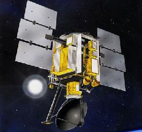
The Phased Array type L-Band Synthetic Aperture Radar (PALSAR) is one of the three remote-sensing instruments onboard the Advance Land Observing Satellite (ALOS). ALOS was launched on January 2006 by JAXA for the purpose of acquiring highly precise observations of land coverage. The satellite uses advance technology to accurately determine spacecraft position and altitude. It is also capable of handling large capacity mission data at high speeds. Since its launch, ALOS data has been used for cartography, regional observation, disaster monitoring, and resource surveying.

Advance Land-Observing Satellite
Phased Array type L-Band Synthetic Aperture Radar
PALSAR Instrument

Instrument Description

The PALSAR instrument is an active L-band microwave sensor capable of operating day-and-night over any weather. Two modes, Fine and ScanSar, allow the sensor to acquire fine resolution data or large swaths at the expense of spatial resolution. In addition, PALSAR makes use of a full polarimetric synthetic aperture radar. Such technology allows for a variety of applications ranging from the determination of soil moisture and vegetation classification, to the monitoring of environmental disasters.


AMSR-E on Aqua

The Advanced Microwave Scanning Radiometer - EOS (AMSR-E) is one of the six state-of-the-art instruments aboard the Aqua satellite. Aqua was launched on May 2002 in support of NASA’s Earth Science Enterprise program. Its primary objective is to gather information about water systems on Earth. Since its launch, the six sensors onboard have acquired data on global precipitation, evaporation, and the cycling of water. Such information is vital for scientists around the world seeking a better understanding of Earth’s water cycle and its dependence on global climate change.


AMSR-E on the Aqua Satellite
AMSR-E Instrument
AMSR-E Instrument

Instrument Description

The AMSR-E instrument, modified from the design used for the ADEOS-II AMSR, is a conically scanning total power passive microwave radiometer sensing microwave radiation at 12 channels and 6 frequencies ranging from 6.9 to 89.0 GHz. At an altitude of about 700 km, AMSR-E rotates continuously at 40 revolutions per minute as it receives horizontally and vertically polarized radiation measured separately at each frequency.


SeaWinds on QuikSCAT
The SeaWinds instrument on NASA’s Quick Satterometer (QuikSCAT) was used as a “quick recovery” mission to fill in the data gap that resulted when the satellite carrying NASA’s scatterometer (NSCAT) lost power in June 1997. QuikSCAT was launch into an elliptical orbit on June 1999 over the Pacific Ocean, where it reached a maximum altitude of about 800 kilometers. Since then, the mission has acquired data measuring near-surface wind speed and direction over Earth's oceans. SeaWinds Logo

Instrument Description

The SeaWinds instrument is a specialized active microwave radar with a rotating dish antenna that radiates microwave pulses at a frequency of 13.4 GHz. Its antenna has two spot beams that sweep in a circular pattern as it collects data across broad regions on Earth’s surface. The instrument has accumulated data over oceans, land and ice in a continuous, 1,800 kilometer wide band, making approximately 400,000 measurements and covering 90% of Earth’s surface in one day.
QuikSCAT Satellite
The QuikSCAT Satellite

JPL Footer
JPL Footer - Feedback Button JPL Footer - FAQ button JPL Footer - Image Policy Button JPL Footer - Privacy Button Mail to: Wetlands