|
|||||
 |
 |
||||||||||||
|---|---|---|---|---|---|---|---|---|---|---|---|---|---|
|
 |
||||||||||||
|
|||||||||||||
|
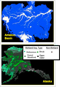
The NASA Earth science project's main objective is the construction of a global-scale Earth System Data Record (ESDR) of inundated wetlands to facilitate investigations on their role in climate, biogeochemistry, hydrology, and biodiversity. The ESDR is comprised of two complementary components. The first component consists of fine-resolution, 100 meter, maps of wetland extent, vegetation type, and seasonal inundation dynamics, derived from Synthetic Aperture Radar (SAR) for continental-scale areas covering crucial wetland regions. The contemporary-era mapping will use newly available data (HH/HV) from the Phase Array L-Band SAR (PALSAR) sensor mounted on the Advanced Land Observing Satellite (ALOS). This satellite, built and operated by the Japanese Space Agency (JAXA), has been collecting data since early 2006. The wetland products will be generated using legacy algorithms already developed and tested with similar datasets. The algorithms are based on an object oriented image segmentation approach and a statistically based decision tree classifier. This approach follows directly from previous work on mapping of tropical and boreal wetlands with SAR data from the Japanese Earth Resources (JERS-1) satellite. The second component is comprised of global monthly mappings of inundation extent at ~25 km resolution. These products will be derived from multiple satellite remote sensing observations including coarse resolution passive and active microwave sensors and optical data sets (e.g. ERS and SeaWindson-QuikSCAT scatterometers, AVHRR, MODIS) optimized specifically for inundation detection. A clustering model and a mixture model comprise the classification and fractional inundation calculations of the algorithm used. The monthly data will be used to construct annual summary products, including maximum spatial distribution and area, and annual inundation duration of inundated wetlands. Comparative analyses of the high-resolution mosaic products and low-resolution inundation mappings will be conducted to harmonize the ESDR components. The 100-meter SAR based datasets of wetland features will be incorporated to validate and quantify the accuracy of the lower resolution datasets to ensure consistency within the ESDR products. Accuracy assessment of the fine scale regional wetlands data sets will take advantage of high-resolution wetlands maps available through collaborators. This ESDR will provide the first accurate, consistent and comprehensive global-scale data set of wetland inundation and vegetation, including continental-scale multi-temporal and multi-year monthly inundation dynamics at varying scales. |
|||||||||||||
 |
|---|