|
Global DEM: Data Specifications
Output Global DEM
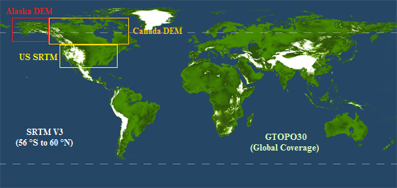
The output global DEM consists of 5 input DEM data sets, which have
been processed and formatted to the consistent configuration
described below. The global product has been mathematically analyzed
and assessed, establishing the following data hierarchy ordered from
highest to lowest quality: US SRTM, Alaska, SRTM V3, Canada, and
GTOPO30. Data files are available as 1 x 1 deg tiles.
|
Output Data Format
|
Dimensions: 3600 x 3600 px
Resolution: 1 arc-second
Pixel spacing: 0.0000277778 deg.
Elevation Units: Meters
Bytes per Pixel: 4 bytes
Format: Geotiff and Binary with header file
Naming: South west corner
Vertical Datum: Same as input
Horizontal Datum: Same as input, Alaska DEM has been shifted to correspond to SRTM
Projection: Geographic
|
|
Data Sets making up the global DEM
|
Input Data Specifications
| Input Data Set: |
US SRTM |
SRTM |
GTOPO |
Alaska DEM |
Canada DEM |
Coverage: |
United States |
56 °S to 60 °N |
Global |
Alaska |
Canada |
| Source: |
NASA JPL |
NASA JPL |
USGS |
USGS |
GeoBase |
| Resolution: |
1 arc-second |
3 arc-seconds |
30 arc-seconds |
2 arc-seconds |
3x6 arc-seconds |
| Horizontal Datum: |
WGS84 |
WGS84 |
WGS84 |
NAD27 |
NAD83 |
| Vertical Datum: |
EGM96 |
EGM96 |
EGM96 |
NAVD29 |
CVGD28 |
| Projection: |
Geographic |
Geographic |
Geographic |
Geographic |
Geographic |
| Acquisition Date: |
February 2000 |
February 2000 |
Late 1996 |
1925 - 1999 |
- |
|